
Announcements
Announcements
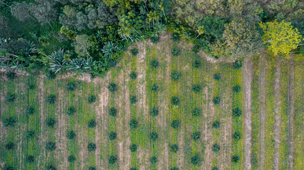
High in the Andes mountain range, well above the treeline, grass and scrub grow on soft, spongy soil dotted with chilly blue ponds. It is a unique tropical alpine ecosystem, the páramo, which covers some 36,000 km2 across parts of Peru, Bolivia, Ecuador, Colombia and Venezuela.
The remote wetlands are crucial to the water supply of farms and towns downstream. Researchers have estimated that 40 million people depend directly on Andean páramos for their water resources. In Peru’s Piura region, near the Ecuadoran border, SEI has estimated that although páramos cover only 5% of the watershed area, they contribute up to 50% of river flows during dry seasons in those watersheds.
“Páramos are a very important source of water,” says SEI Senior Scientist Francisco Flores-López. “They act like sponges, absorbing rain and moisture from the air. The soils are rich in organic matter, so they have high storage capacity – and they release the water slowly but steadily. In the dry season, especially, water from the páramos may be the main source of water for human, animal and agricultural use, and even for hydropower generation in some basins.”
Building on a World Bank-financed study that had emphasized the importance of páramos for water security, SEI set out to build capacity within local communities, government agencies and regional water resource management authorities to conserve and manage páramos in the Piura region.
The first step was to develop a good model of páramo hydrology. Due to the geophysical diversity of the landscape and limited data availability, few studies have modelled the páramos, and those that have looked only at the ecosystems themselves – not on what happens to the water as it flows down from the mountains. Using SEI’s Water Evaluation and Planning (WEAP) system, Flores-López and colleagues developed a more comprehensive model to simulate the impacts of both climate change and human activities, as well as the benefits of potential adaptation measures.
The study focused on the Quiroz-Chipillico watershed, which covers 4,280 km2 with elevations ranging from 65 to 3,950 metres above sea level, and average precipitation ranging from 700 mm per year in the lowlands, to 1,980 mm per year in the high elevations. The landscape varies just as dramatically: from wetlands to desert and savannah-like scrub, pastures, and rainfed and irrigated farmland.
SEI convened 41 local decision-makers, stakeholders from the public sector, research groups and the private sector, and worked with them to identify uncertainties and stressors that affect water availability, potential strategies to address those issues, and metrics by which to judge the effectiveness of each strategy.
The Andean páramos are not well represented in global climate models, but historical data show a clear warming trend; guided the best available projections, the team chose to model temperature increases of 1.5°C and 2.5°C by 2060. Precipitation projections are more variable; SEI modelled a 6% decrease, a 2% decrease, and a 6% increase.
Based on input from the stakeholders, population growth was modelled at 0.9% (as currently projected) and 2% per year. Infrastructure and irrigation system upgrades were projected to improve efficiency by 5% and 35%, respectively, and reservoir storage was assumed to be built. Reforestation efforts were projected to increase forest cover by 30%.
And the páramo areas were projected to shrink by 30%, replaced by cattle grazing land, newly planted pine forest, and expansion of the agricultural frontier – all reflecting observed trends.
As expected, the model showed that rising temperatures and reduced precipitation would affect water availability. But land use change – specifically, the conversion of páramo to new uses and degradation of the páramo – had an even greater effect. Even with a 6% increase in precipitation, water availability could significantly decline if the páramo keeps shrinking. Notably, it is the agriculture sector that would be harmed the most, with a loss of 5–7% in irrigation demand coverage.
“This is an area with limited resources, and agriculture is a key part of the economy,” says Flores-López. “That means it’s essential to preserve the páramo, to protect livelihoods across the watershed.”
SEI shared the model results with the stakeholders, who had an opportunity to examine and discuss them at length. Regional and national government officials were also briefed. Since the project ended, SEI has continued to build capacity in the study area and, through other projects, worked to ensure that the analysis informs water resource management policies.
“Climate change will affect ecosystems all over the world, but in many places, human activities may cause much more harm,” Flores-López says. “We need to raise awareness of these risks among decision-makers and the general public, to encourage them to take protective measures.”
This work is also relevant beyond Peru. “There are páramos in Venezuela, Colombia, Ecuador and Bolivia as well, that could benefit from this type of analysis – and in fact, we are doing similar work in other countries where SEI is active,” Flores-López says. “Páramo modelling capacity is now also part of WEAP, so users outside SEI can also apply this knowledge on their own.”
Read the article (external link to journal; open access)
Other publication / The German economy is linked to significant amounts of deforestation risk, but the majority of this risk results from just five key commodities.
Perspective / Research from SEI and ACTO shows how a new declaration can be strengthened to protect this tropical rainforest, in South America and beyond.
SEI brief / WASH-Flows is an analytical tool to estimate and assess the vulnerability of water, sanitation and hygiene (WASH) services at the household and community level.
Design and development by Soapbox.